


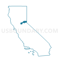
Voting District 50530, Placer County, California
About
Outline

Summary
| Unique Area Identifier | 536706 |
| Name | Voting District 50530 |
| County | Placer County |
| State | California |
| Area (square miles) | 8.40 |
| Land Area (square miles) | 8.40 |
| Water Area (square miles) | 0.00 |
| % of Land Area | 100.00 |
| % of Water Area | 0.00 |
| Latitude of the Internal Point | 39.26792960 |
| Longtitude of the Internal Point | -120.33807910 |
Maps


Graphs
Select a template below for downloading or customizing gragh for Voting District 50530, Placer County, California


Neighbors
Neighoring Voting District (by Name) Neighboring Voting District on the Map
- Voting District 50005, Placer County, CA
- Voting District 50510, Placer County, CA
- Voting District 50550, Placer County, CA
- Voting District 50555, Placer County, CA
- Voting District 50560, Placer County, CA
- Voting District 50740, Placer County, CA
Top 10 Neighboring County Subdivision (by Population) Neighboring County Subdivision on the Map
- Colfax-Monumental Ridge CCD, Placer County, CA (20,351)
- Foresthill-Back Country CCD, Placer County, CA (6,146)